Mapping the Tiny Plankton That Feed Giant Right Whales
Category: Science,
2025-05-11 22:03
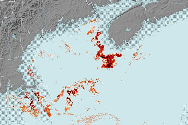
Researchers have utilized NASA satellite data to map swarms of Calanus finmarchicus, a red-tinged copepod that serves as a crucial food source for the endangered North Atlantic right whale in the Gulf of Maine.
In the Gulf of Maine, scientists are employing advanced NASA satellite technology to track and map the distribution of Calanus finmarchicus, a species of tiny, reddish zooplankton. These copepods are a vital food source for the North Atlantic right whale, one of the world’s rarest and most endangered marine mammals. The right whale, which can reach lengths of up to 16 meters and weigh up to 70 tons, relies heavily on dense swarms of these copepods to sustain itself. By filtering vast quantities of seawater through their baleen plates, right whales consume millions of these plankton daily. The research, conducted by analyzing satellite data that detects ocean color and plankton blooms, allows scientists to identify areas with high concentrations of Calanus finmarchicus. This information is critical for conservation efforts, as it helps pinpoint feeding grounds and migration routes essential for the whales' survival. The North Atlantic right whale population has declined to fewer than 350 individuals, primarily due to ship strikes, fishing gear entanglements, and changes in food availability linked to climate change. Mapping the copepod swarms provides valuable insights into the whales’ feeding ecology and can inform strategies to protect both the whales and their habitat. The study highlights the importance of integrating satellite observations with marine biology to address urgent conservation challenges.
Source: NASA Earth Observatory (.gov)
Importance: 75%
Interest: 80%
Credibility: 98%
Propaganda: 2%